The permit for this event is pending.
Advance online registration is required for this event.
Register before Wed Oct 14 end of day (11:59pm)
Online registration link coming here approx 1 month before event date
Quick Info
Courses: Classic point to point orienteering format. Detailed course information will be posted closer to the event date.
Times: Map handout opens at 10:30am. Start your course anytime between 11:00am and 1:00pm. All courses close at 3pm.
Everyone welcome: members, nonmembers, families, pets, and youth groups.
Courses set by: TBA
Event director: TBA
Event overview
Mary S. Young Park may be the most scenic park you never heard of. The western part of the park features a network of trails winding through a cool shady forest. Near the parking areas, a couple of large open fields offer contour detail, trees, bushes, and other features. The eastern part of the park plunges to the Willamette River on trails that negotiate a dramatically eroded landscape. The river's edge has rock formations, sandy beaches, and islands. All courses will use the trail system; so bring your running shoes. Well, for the longer courses, bring older running shoes.
We use an electronic scoring and timing system known as “e-punch” Each entry or team needs to have an e-punch stick. If you don't have your own e-punch stick, you can rent one at registration for an additional $5. Using the e-punch is easy. You can learn how at the event, or read about e-punch here.
CROC thanks our land management partner City of West Linn Parks.
Courses
Course details will be added here closer to the event date.
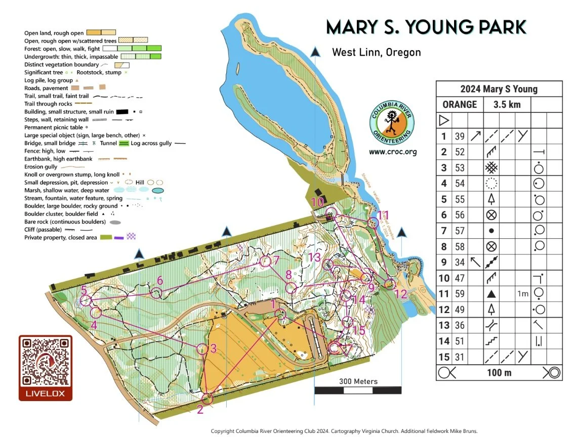
Map example
Here's an example of a map from this venue. (See all maps from previous events here.)
New to Orienteering? Welcome!
Our events are open to both members and non-members. Beginners, families and dogs are welcome.
Have a look at our “New to O?” webpage, which covers just about every question you may have.
At most events, we offer free beginner clinics (they take about 10 minutes) to teach you everything you need to know. These are typically at half-hour intervals; choose your time slot on the registration page.
If you'd like to get reminders about upcoming events, sign up at our newsletter page. (No more than a couple of emails per month, we promise!)
Thanks for coming out and trying something new, we think you'll like it!
Times
Check-in and map pick-up: 10:30 am - 1:00 pm
Beginner clinics: Usually 11:00 am and 11:30 am
Course starts: 11:00 am - 1:00 pm
All courses close: 3:00 pm (controls will be picked up)
All participants must punch in at the finish and download their times even if they do not finish their course, or if they return after the course closes. This is how we make sure that everyone returns safely.
Registration and other costs
Event Cost
$17 base price - individuals
$22 base price - groups of 2 or more
- Subtract $5 if you’re a member or CROC or other O-club (Join CROC)
- Subtract $5 if you have your own e-punch (Buy your own epunch)
Online registration link coming here approx 1 month before event date
Livelox - GPS tracking and route review tool
CROC uses Livelox. This is an interactive web based tool that enables you to see your exact route/track on the orienteering map, and compare them with other competitors after your event.
To use this tool, you need to record a GPX track while you are on the course. You can do this with various watch and phone based apps.
Volunteers
All CROC orienteering events are put on by volunteers, and the meet director can almost always used some extra helpers. Please keep in mind:
No prior experience is needed for many of the tasks
You can help out AND still run your course of choice
Typical ways to assist are: helping with starts, checking in folks at registration, and picking up control flags after the course closes.
If you'd like to help you can choose a task and a time shift when you register online. Thanks!
Results
Times are posted to the Events & Results page a few days after the event.
Map and Driving Directions
45.3804, -122.6278
Latitude longitude coordinates of the event site. Copy and paste these into a mapping app on your phone or Google maps to get a map and driving directions to this location.
From Portland City Center:
Get on Macadam South, which runs along the Willamette River on the west bank. (This road is OR 43)
Go south on OR 43 to Lake Oswego, about 6 miles.
From Lake Oswego, continue south on OR 43 about 2.8 miles to the park.
Follow the orienteering signs to the main loop parking lot at the east end of the park.