
Advance online registration is required for this event.
Register before Wed May 6 end of day (11:59pm)
Quick Info
Courses: Classic point to point orienteering format. (Course details are below)
Times: Check-in opens at 10:30am. Start your course between 11:00am and 1:00pm. All courses close at 3pm.
Everyone welcome: members, nonmembers, families, pets, and youth groups.
This is the 3rd in our 2026 Classic Series competition! Take the best 5 of 7 races throughout the season and see how you compare to others in your category! More information on the 2026 Classic Series page.
Courses set by: Sam Scheiss and Julie Pohl
Event director: Amy Winston
Event Overview
Hamilton Island was initially "discovered" for Americans by Lewis and Clark in 1805, and they named it Strawberry Island. That name was eventually changed to Hamilton Island in honor of a Samuel M. Hamilton, a nearby land owner in the mid 1800s. The island stopped being a real island in the 1970s when construction debris for the Bonneville North Power house filled in one of the surrounding waterways.
The terrain is mostly wide open in all directions with scattered copses. There is one large low hill to go around or climb multiple times. There are marshy areas, some thickets, and shorelines. You can enjoy beautiful river gorge views and lots of wildlife.
You may encounter blackberry vines and thistles. The areas covered by blackberries have been updated somewhat, although mowing may change their configuration or have added a trail or two through patches. Lower leg protection / gaiters are recommended on the more advanced courses.
We use an electronic scoring and timing system known as “e-punch”. Each entry or team needs to have an e-punch stick. If you don't have your own e-punch stick, the rental cost is included in your registration fee. Using e-punch is easy. You can learn how at the event, or read about e-punch here.
CROC thanks our land management partner the US Army Corps of Engineers.
Courses
White: Beginner (2.9 km, on-trail navigation)
Yellow: Beginner/Intermediate ( 3.3 km, on-trail and near trail navigation)
Orange: Intermediate (6.3 km, off-trail, moderate navigational challenge)
Brown: Short Advanced (5.0 km, off-trail, high navigational challenge)
Green: Advanced (8.1 km. off-trail, high navigational challenge)
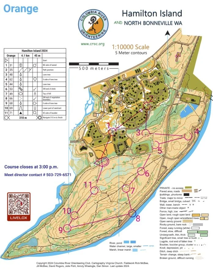
Map example
Here's an example of a map from this venue. (See all maps from previous events here.)
New to Orientering? Welcome!
Our events are open to both members and non-members. Beginners, families and dogs are welcome.
Have a look at our “New to O?” webpage, which covers just about every question you may have.
At most events, we offer free beginner clinics (they take about 10 minutes) to teach you everything you need to know. These are typically at half-hour intervals; choose your time slot on the registration page.
If you'd like to get reminders about upcoming events, sign up at our newsletter page. (No more than a couple of emails per month, we promise!)
Thanks for coming out and trying something new, we think you'll like it!
Times
Check-in: 10:30 am - 1:00 pm
Beginner clinics: Usually 11:00 am and 11:30 am
Course starts: 11:00 am - 1:00 pm
All courses close: 3:00 pm (controls will be picked up)
All participants must punch in at the finish and download their times even if they do not finish their course, or if they return after the course closes. This is how we make sure that everyone returns safely.
Registration and other costs
Event Cost
$17 base price - individuals
$22 base price - groups of 2 or more
- Subtract $5 if you’re a member or CROC or other O-club (Join CROC)
- Subtract $5 if you have your own e-punch (Buy your own epunch)
Livelox: GPS tracking and route reviewing tool
CROC uses Livelox, which is an interactive web based tool that enables you to see your exact route/track on the orienteering map, and compare them with other competitors.
Volunteers
All CROC events are put on by volunteers, and the meet director can almost always use some extra hands. Please keep in mind:
No prior experience is needed for many of the tasks
You can help out AND still run your course of choice
Typical ways to assist are: helping with starts and finishes, handing out maps, and picking up control flags after the course closes. Typical shifts are one hour.
If you'd like to help, you can choose a task and time shift when you register online. Thanks!
Results
Results are posted to the Events & Results web page a few days after the event.
Driving directions and map to event
Latitude longitude coordinates of event: 45.6337, -121.9788
Click for a Google map, or copy/paste these latitude longitude coordinates into Google maps or your smartphone mapping app to get a map and driving directions to the event.
Note:
There will NOT be a CROC sign on Highway 14, as the locals like to (ahem) remove them.
The event center is at the baseball field in North Bonneville, NOT at the parking lot near the river as in the past few years. See directions and map below.
Driving directions from Portland (allow about 1 hour):
Drive east on I 84, take Exit 44 at Cascade Locks.
Cross the Bridge of the Gods into Washington (Toll $2).
Turn left (west) onto Hwy 14 and go approx. 4 miles.
Turn left at the Chevron station in the town of North Bonneville.
In 200 feet, take a right onto Cascade Dr. Follow the blue signs to the ball field. In 0.4 miles, take a left onto Portage Drive. Go to the end of Portage Drive.