The permit for this event is pending.
Advance online registration is required for this event.
Register before Wed June 3 end of day (11:59pm)
Online registration link coming here approx 1 month before event date
Quick Info
Courses: Classic point to point orienteering format. Detailed course information will be posted closer to the event date.
Times: Map handout opens at 10:30am. Start your course between 11:00am and 1:00pm. All courses close at 3pm.
Everyone welcome: members, nonmembers, families, pets, and youth groups.
Courses set by: TBA
Event director: TBA
Event Overview
On the banks of the Willamette River, Champoeg State Park is large and mostly flat. An interesting variety of terrain should make for some fun orienteering! We will use a new start location at the Pioneer Memorial Pavilion to change it up from previous years.
Participants should be aware that there is poison oak in the park, and in some areas, it has invaded the grass. While the Park has undertaken measures to manage it and the courses will be designed to avoid it, it is recommended that participants wear full lower body covering.
We use an electronic scoring and timing system known as “e-punch”. Each entry or team needs to have an e-punch stick. If you don't have your own e-punch stick, the rental cost is included in your registration fee. Using e-punch is easy. You can learn how at the event, or read about e-punch here. For this event, AIR+ is enabled for optional contactless control punching with your Sportident SIAC card.
CROC thanks our land management partner Oregon State Parks.
Courses
Course details will be added here closer to the event date.
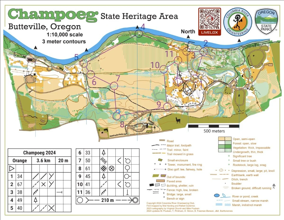
Map example
Here's an example of a map from this venue. (See all maps from previous events here.)
New to Orienteering? Welcome!
Our events are open to both members and non-members. Beginners, families and dogs are welcome.
Have a look at our “New to O?” webpage, which covers just about every question you may have.
At most events, we offer free beginner clinics (they take about 10 minutes) to teach you everything you need to know. These are typically at half-hour intervals; choose your time slot on the registration page.
If you'd like to get reminders about upcoming events, sign up at our newsletter page. (No more than a couple of emails per month, we promise!)
Thanks for coming out and trying something new, we think you'll like it!
Times
Check-in and map pick-up: 10:30 am - 1:00 pm
Beginner clinics: Usually 11:00 am and 11:30 am
Course starts: 11:00 am - 1:00 pm
All courses close: 3:00 pm (controls will be picked up)
All participants must punch in at the finish and download their times even if they do not finish their course, or if they return after the course closes. This is how we make sure that everyone returns safely.
Registration and other costs
Park Fee: Oregon State Parks charges $10 for day use, and $60 for a 12 month pass. The day pass fee may be paid at either the welcome center (one mile after entering the park) or at the "iron ranger" fee box in each parking lot (exact change required.)
Event Cost
$17 base price - individuals
$22 base price - groups of 2 or more
- Subtract $5 if you’re a member or CROC or other O-club (Join CROC)
- Subtract $5 if you have your own e-punch or if you buy one during registration. (Buy your own epunch)
Online registration link coming here approx 1 month before event date
Livelox: GPS tracking and route reviewing tool
CROC uses Livelox, which is an interactive web based tool that enables you to see your exact route/track on the orienteering map, and compare them with other competitors.
Volunteers
All CROC events are put on by volunteers, and the meet director can almost always use some extra hands. Please keep in mind:
No prior experience is needed for many of the tasks
You can help out AND still run your course of choice
Typical ways to assist are: helping with starts and finishes, handing out maps, and picking up control flags after the course closes. Typical shifts are one hour. If you'd like to help, you can choose a task and time shift when you register online. Thanks!
Results
Results are posted to the Events & Results web page a day or two after the event.
Driving directions and location
Latitude longitude coordinates of the event: 45.25532, -122.90483. (Parking at Riverside Day Use area). Copy/paste these latitude longitude coordinates into Google maps or your smartphone mapping app to get a map and driving directions to the event.