
Quick info
- Date: Sunday Sept 16 2018
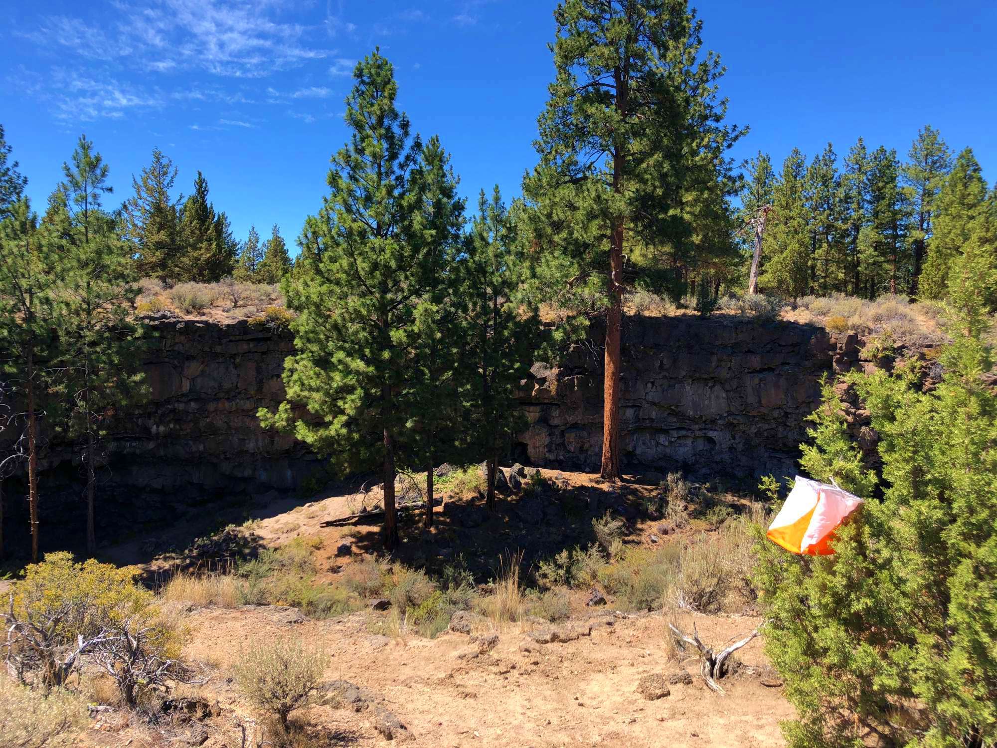
- Location: Boyd and Arnold Ice Caves area, SE of Bend Oregon
- Courses: 3 and 6 hour
- Compete as a team or individual
- See who's registered (plan carpools, hint hint)
- Event director: Pat Gottsacker
Event summary
Join us as CROC returns to the Bend ice caves area, about 20 minutes from beautiful Bend Oregon.
The terrain is central Oregon high desert - fairly flat, with generally open sage and ponderosa pine forest. There are lots of interesting volcanic features, including sunken lava tube caves, small basalt rock outcrops, and overall fairly good runnability in almost every direction. There is a dense network of dirt roads and mountain bike trails, which we will do our very best to map correctly. :-) Elevation is about 4,500 feet. Mid September weather should be moderate (sunny with daytime temperatures in the 70's). Free primitive camping is allowed near the event area on the many US Forest Service side roads.
The map will be an enhanced USGS topographic map, scale 1:24,000, with 10 foot contours.
Here's an example of a map used in a similar navigation race nearby.
Who's registered?
See a list of all participants here. Use this link to plan carpools with other folks in your area, especially our many Seattle friends coming from Cascade Orienteering Club (COC).
(Among many racers: Eric Bone and Alison Crocker, both USA national team members.)
First time at a navigation race?
Welcome! If you are fairly fit, and know how to read a map and the basics of using a compass, you can do this.
- Have a look at this excellent first timers guide from our friends at Mergeo orienteering in Seattle
- Check these Top Ten Navigation Race Beginner Tips
- Attend our beginner clinic the morning of the event, from 830 till about 9 AM. We'll quickly cover the basics of map reading and the core compass skills helpful for the event
- Measuring a bearing from a map is the main compass skill that will be helpful. Learn it here, from a short video on from our Youtube channel: https://www.youtube.com/watch?v=yXYckBuKn1Q&t=2s
- and attend our Sept 8 route planning workshop, see below
Pre-event workshop: Route Planning for a Navigation Race
- Saturday, September 8, 2018
- Time: 9:30-11:00 a.m.
- Location: in SE Portland, location told when you register
Here’s an opportunity to learn, exchange information, and practice designing your team route for a 3- or 6-hour navigation race. We’ll look at team goals and capability, and at considerations for planning your route. We’ll look at successful routes from other navigators, and we’ll practice in pairs making the best plan route using maps from a prior navigation race. No cost for CROC members.
Register prior to September 5 to find the meeting location and to reserve a map by emailing Anndy.
How it works
About 30 control points are placed over approximately 16 square miles at various natural features. These locations are circled on a map, described on the map (eg “hilltop”, “spur” etc.) and marked on the ground by orange and white orienteering marker flags. Each control has a point value, which is equal to the checkpoint number rounded down to the tens place. For example, a checkpoint numbered 35 is worth 30 points, while a checkpoint numbered 72 is worth 70 points. (Generally, points farther away from the start area have a higher point value.) Unless you are an expert orienteer and an extremely fit runner, you will not find all the control points within the time period. So, plan your course to get the most points, not necessarily to find the most total controls.
- For both fun and safety, this is intended as a team event (2-5 people). However, you may compete as an individual if you have prior orienteering experience.
- Participants under 18 years old must be on a team or 2 or more.
- Maps and geocaching coordinates are issued about 1 hour before the start, so teams have time to plan their route.
- You may visit the controls in any order.
- There are no age or gender divisions.
- There are large point penalties for returning late, be sure you return under the time limit.
- Electronic punching (epunch) will be used. Epunch equipment rental is included with your event fee. Read more on epunch here.
- There will be portable toilets, but no running water at the event start, so please bring all water you may need.
- There is limited cell phone coverage at the event area.
- There will be water on the course at certain controls for you to refill, along with snacks and drinks at the finish area.
Location and directions
Here’s a Google map of the approximate start area:
Here are longitude coordinates (in decimal degree format) of the approximate event start area. Copy paste these into Google or a mapping app to get a map and directions.
43.9381, -121.1994
Driving directions (from Portland)
- Drive south through Bend on Hwy 97.
- A few miles south of town, take exit 143.
- At the T intersection at the Country Store, set your odometer.
- Take a left onto Knott and drive 1.4 miles to China Hat Road, a four way intersection.
- Take a right onto China Hat Road, and zero your odometer again.
- Go 8.3 miles to the turn off to Boyd Ice Caves. Take a left and go about 1/4 mile. Look for "orienteering event" signs. (If the paved road turns to gravel, you’ve gone about 100 meters too far.)
Schedule - Sunday Sept 16
- 7:30 am to 9:00 am - check in and day-of-event registration
- Beginner clinic - 8:30 to 9:00
- 9:00 am - map (and geocaching coordinates) handouts
- 9:45 am - event briefing
- 10:00 am - mass start for both courses
- 1:00 pm - 3 hour course closes
- 4:00 pm - 6 hour close closes
Cost (per person) and Registration
3 hour event, ADULTS (18 and older):
- early registration: July 20 - Sept 1: $35
- late registration: Sept 2 - Sept 13: $40
- event day registration on site: $45 (cash or check only)
6 hour event, ADULTS (18 and older):
- early registration: July 20 - Sept 1: $50
- late registration: Sept 2 - Sept 13: $55
- event day registration on site: $60 (cash or check only)
3 hour event, (JUNIORS 17 and younger):
- early registration: July 20 - Sept 1: $20
- late registration: Sept 2 - Sept 13: $25
- event day registration on site: $30 (cash or check only)
6 hour event, (JUNIORS 17 and younger):
- early registration: July 20 - Sept 1: $35
- late registration: Sept 2 - Sept 13: $40
- event day registration on site: $45 (cash or check only)
Rules and Safety
- Team members must stay together (within verbal contact) the whole time they are on the course.
- All team members must go to each checkpoint visited by the team, meaning all must simultaneously approach within 20 meters.
- A whistle is required for all teams.
- Carrying a mobile phone is strongly encouraged for safety. Cell coverage is decent if you can find high ground. (If you are late, we will try calling your phone.)
- The map handout (about 9:00am) does not designate the start of the event (10:00am). Even if you quickly finish planning your route, you may not leave the start area until after the pre-race briefing and the race director shouts GO at the designated start time.
- All participants are required to assist a competitor who is injured and needs assistance.
- 100 points per minute will be deducted from the scores of late returning teams, ouch! Teams finishing more than 20 minutes late will receive a score of zero.
- If you are in the 3 hour category and you finish in more than 3 hours, you are automatically moved to the 6 hour category. Conversely, if you are signed up for the 6 hour category and you decide you have had enough fun after a couple of hours, you can come in early and you will be moved to the 3 hour category. If you do this, please tell the registration desk your change in plans.
- All participants under age 18 must be accompanied by an adult parent or guardian.
- For the map and compass division, GPS devices and altimeters (such as GPS tracking watches) may be carried on the course (to allow tracking analysis afterward) but not used for navigation.
- All participants must register and sign the liability waiver before entering the course.
- All teams must check out through the course finish area before leaving the venue, even if the team does not finish the course or returns after the course closes.
- Teams will fill out an "intention sheet" before the event, showing their approximate intended course. If you are not back by 4:30, we will use this intention sheet to start a search party. We will call your mobile phone first, so if you are late, turn it on.
- Some parts of the course involve scrambling over low but potentially unstable rock formations. While this rock may appear to be solid, it often is not! USE CAUTION if scrambling on any rock formations!
What to Bring
- sturdy shoes, trail runners or light hikers recommended
- socks (ideally a brand new pair to help ensure Happy Feet)
- long pants, tights or shorts with gaitors for lower leg protection
- watch
- whistle
- hat with a visor or brim
- sunscreen and lipbalm
- compass, and maybe second as a backup
- hydration pack or fanny pack
- water bottle(s), or water bladder, already filled
- electronic punching stick, aka estick, if you have one (if not, we provide these free as part of your entry fee)
- pen, pencil and highlighter marker(s) to plan your route
- extra water
- quick bite snacks, energy bars, gel, etc.
- post race snacks
Volunteers
If you would like to volunteer for this event, we can certainly use a few extra hands for course vetting, course setting and course pickup. Please contact meet director Pat Gottsacker at the email at the top of this page if you would like to help.