
ADVANCE ONLINE REGISTRATION IS REQUIRED FOR THIS EVENT.
Only CROC members can register for this free event but they can include family or friends on their team.
Participants must sign event waiver to complete their online registration.
Quick info
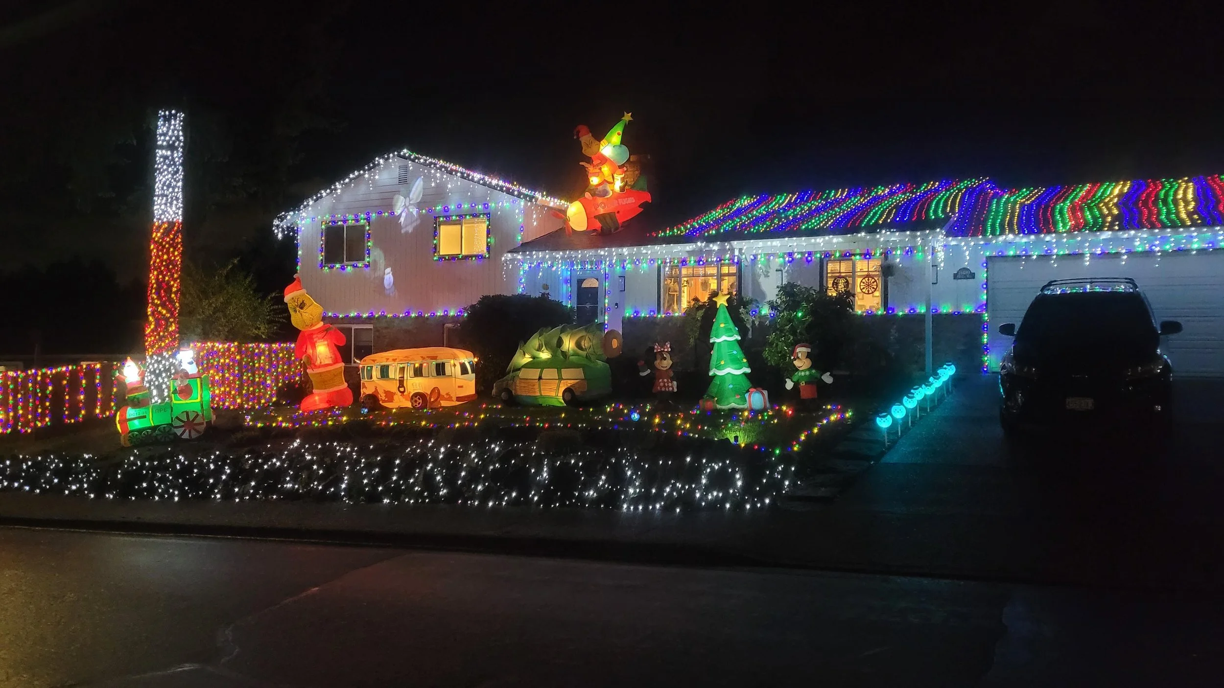
Enjoy a FREE orienteering event featuring holiday decorations in Beaverton.
Score-O format: visit the controls in any order you want. Choose between 60, 120, and 180 minutes on the map.
Use the MapRun smartphone app to “punch” each control (no Q&A sheet).
Look at your map and plot your course before you start.
This course uses about 35% of the Sexton Mountain map covering flats and hills.
There are no volunteers at this event--you do your course on your own whenever you like.
Daylight runners can see some lit decorations if they start after 3 PM.
Night runners get the best view of lit decorations, but must be extra careful when crossing streets.
No beginner clinics. Team captains can give their own clinics if needed to team members.
Dress for cold and wear reflective clothing. Flashlight or headlamp is recommended for evening participants. Smartphone is required if you are using the MapRun app.
Control sites have decorations but not all decorated houses are control sites. Many houses were decorated after the course was set.
Control point values are equal to the tens digit in the control number (control 34 is worth 30 points; control 101 is worth 100 points).
You can do this event alone or as a team. Teams are recommended for safety and for maximizing enjoyment.
Event Director/Course Setter: Tony Pinkham
EVENT OVERVIEW
Happy Holidays and thank you for your CROC membership!!! This event is our thanks for your helping make CROC the wonderful club that it is. This is a FREE event for CROC members, who can have friends and family team up with them.
Your map shows where there are lit holiday decorations, and it lists the address numbers for those sites in the control descriptions. Instead of having to answer questions about each control site, the MapRun app on your smartphone will sound a chime to give you credit for each control found. You get 8 hours to find as many controls as possible in any order, which is more than enough time to find all the controls. You don't have to find all of the controls--just do what is fun for you.
Dress warmly, wear reflective clothing, bring a flashlight, and fully charge your phone for this event. After you register and sign the event waiver, you will receive a MapRun passcode for this event and a PDF file of the event map. Print the color map and bring it with you (if you don't have a printer, print the map at an Office Max, FedEx, or Staples store for less than $0.70). To protect the map from rain or sweaty hands, we recommend a gallon plastic bag or map case. Consider using a smartphone holder for your arm or belt, so your hands are free and your phone is safely held while still being able to receive GPS signals.
The start and finish locations are located very close to the start and finish used at the Sexton Mountain event in November.
Park on SW Rigert Road by the Westside trail in Hart Meadows Park.
The start is about 20 meters north of the road on the paved trail by the NW corner of the power pylons.
The finish is located on the other side of the road on the paved trail by the NE corner of the tennis courts.
These locations are unlit at night but they are close to the road and were chosen so that MapRun would not accidentally start or finish your course when you drove up to this location or ran by on the road. After you start your course, stay at least 10 meters away from the NE corner of the tennis courts until you are ready to finish your course (if you get too close to the tennis courts, MapRun will think that you are finishing your course).
As always, stay off of private property (shown as light olive green on your maps). Public schools with open gates can be accessed when the schools are not in session. If you go through an unlocked, closed gate, then be sure to close the gate after you go through it.
Results will be posted on the MapRun event page and updated as each person finishes the course. CROC will provide results for anyone doing the course by December 31.
If you know of another area with lots of interesting holiday decorations, let Tony Pinkham (runnerinwoods@gmail.com) know about that area and maybe it will be used for our 2024 holiday lights event.
TO SET UP THE MapRun APP ON YOUR PHONE
Install the MapRun app onto your phone (you must be within range of WIFI or phone mobile service):
Go to the Apple Store or Play Store and install the MapRun app (version 7 is recommended).
Use your phone settings to be sure that its location function is turned on.
Setup the 2023 CROC Holiday Lights event on your phone (must be within range of WiFi or phone mobile service):
Be sure that your smartphone volume is turned on to a high setting.
Open the MapRun app.
Using the MapRun home screen, press either the Events Near Me button or the Select Event button.
Find and select the 2023 CROC Holiday Lights event by selecting a country (USA), state (Oregon), region (Portland Metro), and county (Washington).
You may be asked to make a user profile in MapRun, with your name, email, and some other contact info.
If you tap “Go to Start”, you may be asked for a four digit passcode, Enter the code sent to you after you fully registered for this event.
The home screen will reappear with 2023 CROC Holiday Lights listed below the Select Event button.
Print a copy of the event map (the PDF file sent to you after you registered for this event).
To run your course:
To start your course:
Use the Goto Start button on the MapRun home screen to show you directions to the start. Use that map to move the red dot (you) to the purple triangle (start). When you reach the start location (NW corner of the power pylon in Hart Meadows park by SW Rigert Road), MapRun will sound a chime and your clock has started for your course. Use the map that you printed to find each control.
When you are asked for a passcode, enter the code sent to you after you registered.
When you arrive within 5 meters of each control (the location is the same as the address listed for that control in the control descriptions), MapRun will sound a chime and the screen control circle will change from purple to green. If the chime doesn't occur, you might have to walk up and down the sidewalk in front of that house or possibly in the street.
To finish your course:
When you are ready to finish your course, go back to the start area, but go across the street to the NE corner of the tennis courts.
When you reach the NE corner of the tennis courts, MapRun will sound another chime and the screen will indicate that you have finished your course. Your results will be listed with the results for everyone else by the MapRun app.
TIMES
You can do this course any time and day until December 31, 2023. After December 31, when most of the decorations disappear, the course will be closed for results, but you can still do the course without results on the CROC website while using the MapRun app.
REGISTRATION
Advance online registration is required. There is no event day registration and there are no event fees. This is a free event for CROC members.
Registration deadline: 11 PM on Friday, December 29, 2023.
Registration requirements:
CROC membership for the person registering (team captain)
Signing the event waiver (everybody on a team). Anyone who joins a team without signing a waiver is NOT part of this event.
Adhering to waiver provisions--this is an unsupervised event, which means that you are fully responsible for your behavior and safety.
Registration confirmation:
The registering person receives a MapRun passcode and a PDF map file for printing.
If you don't receive this confirmation or have questions, contact Tony Pinkham at runnerinwoods@gmail.com or call by phone (8 AM to 10 PM) at 650-793-8764.
RESULTS
Timed results will be posted on the MapRun website, which is updated with each person or team that finishes. CROC will publish results after December 31.
MAP AND DIRECTIONS
45.4602, -122.8411
Copy/paste these latitude longitude coordinates into Google maps or your smartphone mapping app to get a map and driving directions to the event.
Starts and finishes occur at Hart Meadows park. Parking is on SW Rigert Rd. where it goes through Hart Meadows park.
Try a Google maps search for “Hart Meadows park”
To get to Hart Meadows Park by car:
Take Highway 217 to SW Allen Blvd (exit 2B).
Go west on SW Allen for 1.7 miles to SW Murray Blvd.
Turn left onto SW Murray Blvd. and go 0.8 miles to SW Hart Rd.
Turn right onto SW Hart Rd. and go 0.5 miles to SW 155th Ave.
Turn left onto SW 155th Ave. and go 0.3 miles to SW Rigert Rd.
Turn right onto SW Rigert Rd. and go 0.2 miles to Hart Meadows park.
Park on the street.
The start is located on the paved walkway that goes by the NW corner of a power pylon about 20 meters north of SW Rigert Road.
The finish is located on the paved walkway that goes by the NE corner of the tennis courts about 20 meters south of SW Rigert Road.
